


Highway Safety Corridors
About the Program
Some stretches of highway are more challenging to drive than others. Roadway, traffic, weather, inattention and distractions all come into play for drivers.
Fatalities on Virginia’s roadways have increased from a low of 700 in 2014 to 968 in 2021, a 38 percent increase. On our interstates, fatalities have increase over 50 percent during the same period. Even with decreased travel during the pandemic, police have recorded more speeding and distracted driving on crash reports.
An Interagency Effort
To combat the severe crashes occurring on Virginia's highways, the 2003 General Assembly directed three state agencies - Virginia State Police, Department of Motor Vehicles and Department of Transportation - to create a highway safety corridor program that addresses safety in high crash locations on interstate and primary roads (routes numbered 1 through 599).
Highway Safety Corridor Regions
Beginning with the interstate system of highways, Virginia is divided into three highway safety corridor regions:
- Region 1 - West: Encompasses the entire Interstate 81 corridor and includes 483 interstate miles
- Region 2 - Southeast: Encompasses the Central Virginia region to the southeastern borders of the state and includes 432 interstate miles
- Region 3 - Northeast: Encompasses the northern part of the state east of I-81and includes 214 interstate miles
Designated segments of interstates in each region have been identified as having higher-than-expected crash rates and crash severity, including injuries and fatalities. The three agencies combined crash data with public comment to determine the location of the initial three Highway Safety Corridors.
Where are the Highway Safety Corridors?
Interstate 81, Montgomery and Roanoke counties
The first Highway Safety Corridor is a 15-mile section of I-81 between mile marker 127, near Ironto in Montgomery County, and mile marker 142, near Salem. Speeding and heavy truck traffic have contributed to this area's designation.
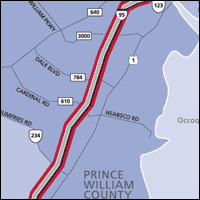
Interstate 95, Northern Virginia
The second corridor covers 11 miles of I-95 in Northern Virginia, from Route 619 at Triangle to Route 123 at the Occoquan River. Aggressive and inattentive drivers with many congested period have made this road worthy of being named a corridor.
Interstate 95, Richmond
The third corridor is a 13-mile stretch of I-95 that extends from Bells Road in the southern part of Richmond to Parham Road north of the city. This area became a corridor after posting a crash rate more than twice the state average.
Click an image below to view a larger PDF version of the map for each corridor:
Interstate 81: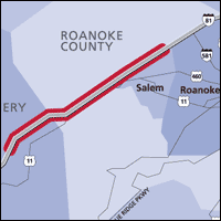
Interstate 95 Richmond: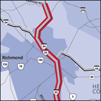
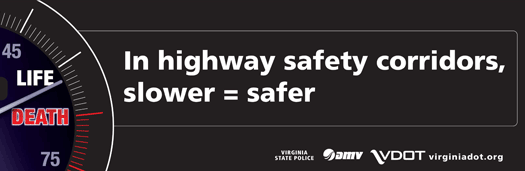
Slow down - phone down- buckle up!
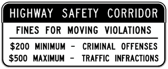
Tickets for speeding and other traffic infractions could result in fines up to $500 in Highway Safety Corridors. Criminal offenses, such as reckless driving or driving under the influence, could result in fines up to $2,500.
Program Criteria and Policy
- Why should a segment of highway be a Safety Corridor?
- How is a Highway Safety Corridor designated?
- What should the measure of success be for this program?
Criteria
To initiate the program, 1100 miles of interstate freeways were assessed for several safety (crash-related) measures within each of the three regions. Based on the crash data analysis, the following criteria were used:
- Crash severity per mile
- Overall vehicle crash rate per 100 Million Vehicle Miles Traveled
- Large truck involved crash rate per 100 Million Truck Miles Traveled
Additional Possible Criteria
The following additional criteria were suggested at public meetings held during the fall of 2003:
- Speeding
- Ease of enforcement
- Topography
- Lighting, shoulders, guardrail
- Potential effectiveness of engineering solutions
- Projects in VDOT's Six-Year Improvement Program
- Length of corridor and/or number of jurisdictions affected
- Public interest/perception
- Funding or other means for developing countermeasures
Policy
Following the public meeting on selecting criteria to designate a Highway Safety Corridor, the crash data was reviewed again based on comments that were received. The following policy was selected for interstate highways in each of the three regions.
The statute requires that the following criteria be used in selecting a Highway Safety Corridor:
- Review of crash data
- Crash reports
- Type and volume of traffic
- Engineering and traffic studies
To comply with the statute, the following criteria are used to identify a candidate Highway Safety Corridor on interstate highways:
- The crash frequency, weighted by severity, should be at least 50 percent more than the regional average for the highway system.
- The crash rate should be at least 25 percent more than the regional average for the highway system.
- The truck-involved crash rate should exceed the average crash rate for that region for all vehicles on the highway system.
- Enforcement capability
- Roadway characteristics
Rules for Public Hearings
The following rules shall be observed concerning public hearings prior to the selection of Highway Safety Corridor:
- The commissioner shall hold a minimum of one public hearing before any designation is implemented.
- The public hearing or hearings for a specific candidate Highway Safety Corridor shall be held at least 30 days prior to the designation at a location as close to the proposed corridor as practical.
Designated Interstate corridors
 Highway safety corridor signs are posted at the beginning of a designated zone and after every interchange entry to indicate that increased moving violations fines apply when driving in a designated highway segment.
Criteria for designating corridors are actually measures of safety. Within each region, the crash severity weighted frequency and crash rate criteria were overlaid where they exceeded the established thresholds.
Crash data for Highway Safety Corridors
Crashes within the designated interstate corridors have been tracked by the severity of the outcomes. The charts below provide the number and percent of Fatal and Injury (F+I) crashes and the property Damage Only (PDO) crashes within each corridor. The after period has been split into two periods: the first and last five years after the HSC designation. Note: the crash reductions in 2020-21 were primarily due to reduced travel during the pandemic.
I-81 Salem HSC: Years beginning January 13th (NB & SB MP 127 to 142)

I-95 Richmond HSC: Years beginning January 7th (NB MP 69.9 to 83.8 and SB MP 69.9 to 83.5)

I-95 Prince William HSC: Years beginning March 18th (NB MP 149 to 159.7 and SB MP 150.1 to 160)

Contact
For additional information or questions regarding Highway Safety Corridors, please contact:
Stephen Read, P.E.
804-786-9094
Stephen.Read@vdot.virginia.gov
Highway Safety Planning Manager