Studies: Route 631 (5th Street/Old Lynchburg Road) Corridor, Charlottesville & Albemarle
Cost and schedule ►

Study Details
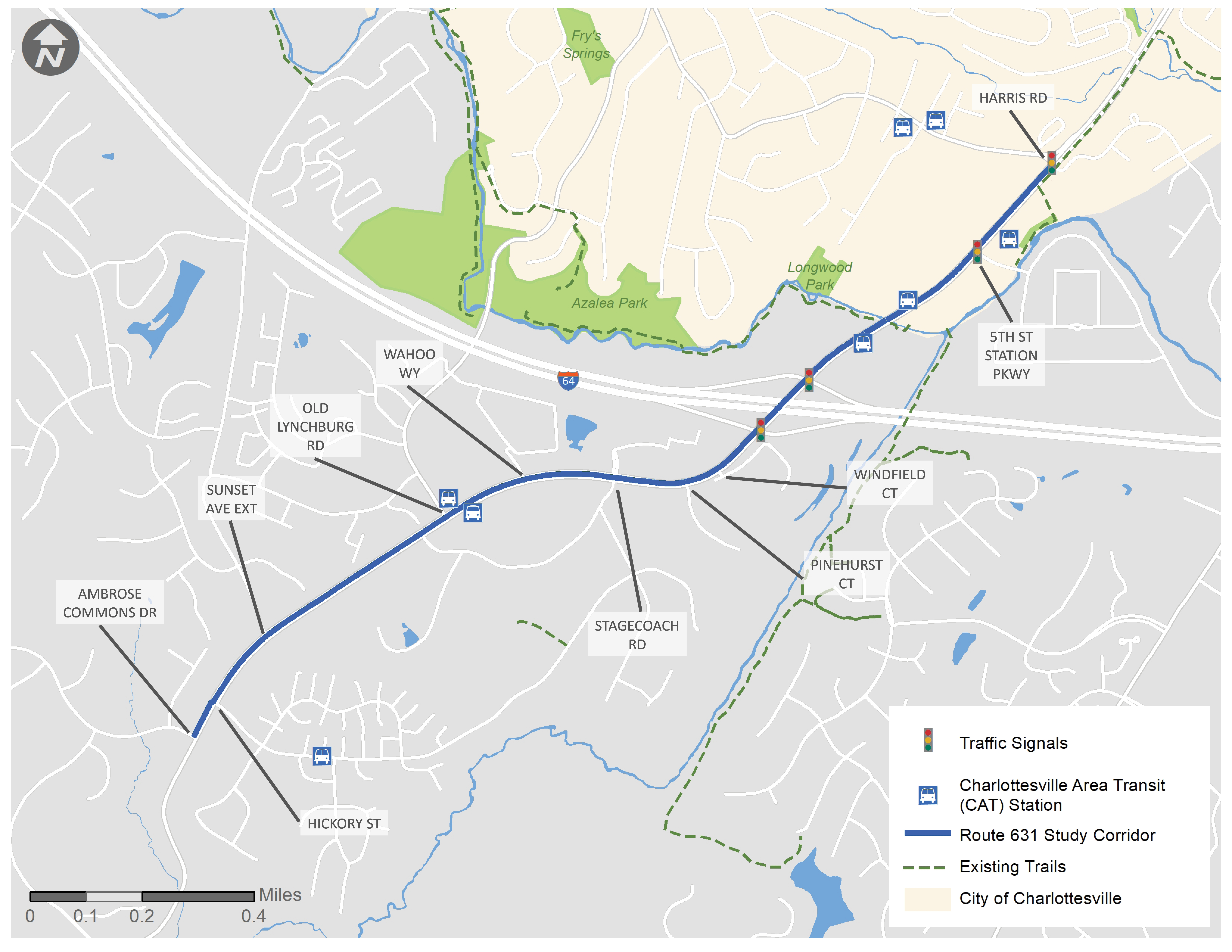
The Route 631 (5th Street/Old Lynchburg Road) corridor improvement study (the study) will evaluate automobile, transit, bicycle, and pedestrian conditions along Route 631/5th Street between Harris Road and Ambrose Commons Drive in the City of Charlottesville and Albemarle County. The study will assess future travel projections and development patterns.
The study vision is for Route 631/5th Street to develop as a Complete Street that supports development and provides safe and comfortable travel for all uses and users of the roadway.
The study will be done in two phases:
- Phase one, which was completed in summer 2019, convened a group of stakeholders that identified consensus goals and the scope of the study.
- Phase two will identify the transportation solutions that will help meet the vision and goals of the study.
Study Goals
1. Improve safety and comfort
2. Manage congestion
3. Support economic development
4. Support environmental sustainability and community health
This study is supported by a stakeholder group made up of representatives from the City of Charlottesville, Albemarle County, the Thomas Jefferson Planning District Commission (TJPDC), the Charlottesville‐Albemarle Metropolitan Planning Organization (CA‐MPO), Charlottesville Area Transit (CAT), and the 5th and Avon Community Advisory Committee.
Online Public Meeting Presentation/FAQ
A webinar was held on June 4, 2020 to provide an update on the 5th Street study. The recorded webinar and frequently asked questions (FAQ) document are available below:
Frequently Asked Questions  (602 KB)
Final Report
The final report for the 5th Street corridor improvement study  (5 MB), published in January 2021, includes recommendations for:
- Two signalized intersection improvements
- One roundabout conversion
- One restricted crossing u-turn (RCUT) conversion
- Consistent, continuous bicycle and pedestrian facilities
- A Project Development and Environmental Study for a redesign of the 5th Street and I-64 interchange
- Multimodal network connections at Sunset Avenue Extended Bridge, from Stribling Avenue to Sunset Avenue, and via the Biscuit Run Stream Valley Trail
View the Executive Summary  (5 MB) for more information.
Benefits
The purpose of the study is to develop short‐, mid‐, and long‐term community‐supported transportation solutions to provide safe and comfortable travel for all uses and users of the roadway. These conceptual transportation solutions may be eligible for funding resources, including VDOT’s SMART SCALE program.
Resources
Chuck Proctor, Culpeper District Planning Manager
(540) 829-7558
Other relevant links:
Frequently Asked Questions  (602 KB)
Technical Memo: Alternatives Analysis  (10 MB)
Existing and Future No-Build Condition Report, April 2020  (7 MB)
Phase 1 Public Engagement Report, April 2020  (10 MB)
Phase 2 Public Engagement Report, January 2021  (11 MB)
English Fact Sheet  (618 KB)
Spanish Fact Sheet  (605 KB)
Lat/Long: 38.014551, ‐78.499987 to 37.999555, ‐78.528170
Locality:
Albemarle


