The Planning Data Solutions (PDS) section in Virginia Department of Transportation's Transportation Mobility Planning Division has unique planning and engineering expertise, which include, but are not limited to, the following:
Managing planning database systems to ensure database structures are stable and contain up-to-date information;
Developing and maintaining planning data applications including the Statewide Planning System (SPS), Planning Web Tools (ENTRADA, LHD, HUBCAP, D-LITE, and LUCI), and Pathways for Planning (P4P);
Conducting GIS analysis and creating georeferenced maps for major initiatives, including SMART SCALE, fall transportation meetings, and spring public hearings;
Supporting data-driven performance measurement studies, such as HPMS, MAP-21 and major funding proposals. The PDS section has also provided statewide technical training to VDOT divisions and districts, FHWA, DRPT, MPOs, and PDCs on the use of TMPD data.
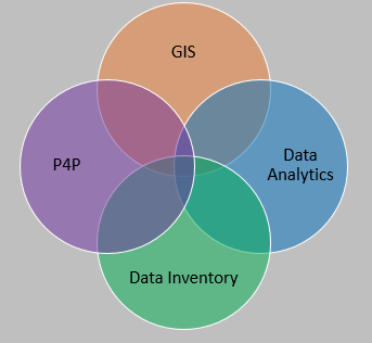
The Planing Data Solutions (PDS) is comprised of three specific functions: GIS, Data Analytics, Planning Application Development.
The GIS team enhances planning processes with the development and maintenance of planning-specific geospatial data for critical decision making. While providing outstanding customer service, the GIS group members support the geospatial needs of TMPD and District Planners through the integration of innovative ideas and incorporation of the latest technology, which is balanced with proven planning analysis. The group produces georeferenced custom maps, including story maps on ArcGIS Online, for Central Office, District Planners, and others. Working groups have been created in ArcGIS Online that enable statewide collaboration.
In addition to the GIS team, the PDS section has an excellent data analytics team, which develops transportation performance measures for mobility, congestion, reliability, and safety. This group evaluates the measures that aid decision-makers in establishing the priority of statewide transportation improvement programs. Team members also coordinate district planning activities for urban, rural and statewide programs; they provide technical assistance, guidance and leadership to district staff. Additionally, this group participates in transportation planning studies including corridor studies, access management studies, crossover studies, interchange studies, etc. The group meets with other division data owners to foster interdivisional cooperation and improve the integration of multiple data sources (SPS, TMS, Crash, iPeMS, INRIX, SMARTSCALE, and NPMRDS) with data management tools.
Last, but not least, the PDS section includes the planning application development team; the team’s responsibilities include development and maintenance of the Statewide Planning System (SPS) application and building the Pathways for Planning (P4P) web-application system, which is designed to provide planning-level GIS analysis and easy access to GIS data files. This team manages data required for planning applications, ensures integration with agency data sources, and provides information required for federal and state reporting, such as HPMS, SMART SCALE, and MAP-21. Group members lead the development, application, and maintenance of statewide planning data such as functional classification, National Highway System, Corridors of Statewide Significance datasets; the team then incorporates these data-sets, along with environmental and socio-economic needs data, in planning and travel demand models.


P4P Planning Tools Smart Scale Functional Class
Planning Data Solutions (PDS) Staff
Jungwook 'JJ' Jun: Section Manager
Ian Turner: GIS, Database, Python, AGOL, Conflation
Qiaomin Zhang: Statistics, Data Analysis, Dashboard, R, and Python
Qingyu Ma: MAP21, P4P, Dashboard, GIS, Smart Scale Scoring
Wayland Colwell: GIS, Access Point Inventory
Charles Leaton: GIS, Database, Python, AGOL, Cartography
Sreehari 'Sree' Kottoormadam: GIS, Database, Programming, HPMS, SPS, Web Application
Kevin McCarthy: GIS, P4P, UI, Web Application
VACANT: GIS, Database, Programming, P4P, Web Application
====================================================================
TDM | P&R | Bike & Ped | STARS | AADT & VMT | VTrans | P4P | FC | Smart Scale
VTrans | OIPI
If you have questions about the Planning Data Solutions Section, please contact Jungwook 'JJ' Jun.