Studies: Route 220 Preservation and Improvement Plan
Cost and schedule ►
Traffic alerts ►
Public outreach ►
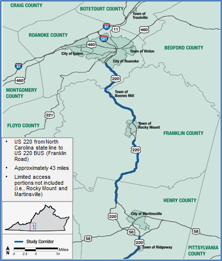
The purpose of the plan is to help localities and VDOT to identify strategies to preserve capacity, enhance safety and support future growth along the Route 220 corridor between the North Carolina state line and Route 419 in Roanoke.
Preliminary design concepts to enhance mainline traffic flow and improve safety include restricting median crossovers and minor intersection turning movements and improving traffic signal operations along the Route 220 corridor.
A series of public meetings were held in Roanoke, Franklin and Henry Counties in November 2019. For more information about the plan and alternative improvements for the corridor, visit the links below:
Arterial Preservation Plan
Alternatives and Concepts for Route 220
- Corridor Recommendations for Route 220
- Intersection Recommendations for Route 220
- Innovative Intersections Handout (Thru-Cut, R-Cut)
- VIDEO: VDOT'S Innovative Solutions to Reduce Congestion and Improve Safety (Thru-Cut Option)
- Information About R-Cuts
- VIDEO: Restricted Crossing U-Turn (R-CUT)
Arterial Preservation Plan
The purpose of an Arterial Preservation Plan is to develop a holistic approach that identifies ways to ensure the safety and preserve the capacity of the Commonwealth’s arterial highway network without wide scale roadway widenings. This Plan has been requested to identify investment recommendations that will help preserve and enhance this key transportation corridor due to the important role it plays in the region as a significant freight and tourism corridor.
Lengths and Limits
The study area is approximately 60 miles in length and extends from the North Carolina line to Route 419 in Roanoke. It includes two limited-access bypass segments at Martinsville and Rocky Mount that are considered to be improved and therefore will not receive analysis as part of the plan.

Stakeholders
Localities involved in the plan include Franklin County, Henry County, Roanoke County, City of Roanoke, Town of Boones Mill and the Town of Rocky Mount. In addition to the localities involved, the Roanoke Valley-Alleghany Regional Commission (RVARC), Roanoke Valley Transportation Planning Organization (RVTPO), and the West Piedmont Planning District Commission (WPPDC) are also critical stakeholders of the project.
Benefits
Improve safety. Increase capacity via widening.
Major Milestones
Public meetings have been held in July 2018 and November 2019.
Resources
Michael Gray
540-494-8288
Videos:
VIDEO: Restricted Crossing U-Turn (R-CUT)
VDOT: Innovative Solutions to Reduce Congestion and Improve Safety
Phase: Underway
Lat/Long: 37.116967, -79.956794
Locality:
Roanoke


